


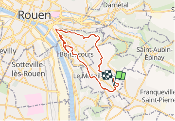
20181127-Le Mesnil Esnard

doudet
User

Length
13.8 km

Max alt
209 m

Uphill gradient
215 m
Km-Effort
16.6 km

Min alt
49 m

Downhill gradient
215 m
Boucle
Yes
Creation date :
2019-01-16 10:37:15.264
Updated on :
2019-01-16 10:37:15.264
3h33
Difficulty : Medium

FREE GPS app for hiking
 SityTrail
IGN / Geographical institutes
SityTrail Plus
The world is yours!
About
Trail Walking of 13.8 km to be discovered at Normandy, Seine-Maritime, Le Mesnil-Esnard. This trail is proposed by doudet.
Description
Boucle A-R au départ du Carrefour Market
Photos


Positioning
Country:
France
Region :
Normandy
Department/Province :
Seine-Maritime
Municipality :
Le Mesnil-Esnard
Location:
Unknown
Start:(Dec)
Start:(UTM)
365850 ; 5474377 (31U) N.
Comments